Nexora Mapالخريطة الجغرافية 2.5DGeo Map 2.5D
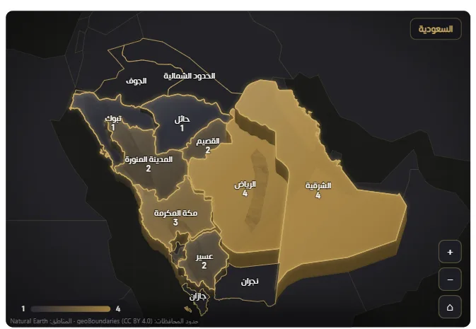
خريطة تفاعلية للسعودية والعالم تعمل دون خدمات خارجية: 13 منطقة و147 محافظة، و191 دولة بحدودها الداخلية، مع تلوين بالقيم وتنقل من الدولة إلى مناطقها.An Arabic-first command map of Saudi Arabia and the world that works offline — 13 regions, 147 governorates and 191 countries with internal boundaries, in a 2.5D view or on a globe.
- 13 منطقة و147 محافظة بحدود مدمجة13 regions and 147 governorates with embedded boundaries
- تلوين المناطق بحسب القيمةValue colouring (choropleth) with glowing borders
- 191 دولة بحدودها الداخلية المدمجة191 countries with embedded internal boundaries
ما الذي تضيفه الأداة؟The problem it solves
لماذا الخريطة الجغرافية 2.5D؟Why Geo Map 2.5D?
تحليل البيانات جغرافيًا داخل السعودية يحتاج إلى أسماء وحدود دقيقة وتجربة تعمل في البيئات المؤسسية. توفر Nexora Map خريطة مدمجة تعرض المناطق والمحافظات وتدعم التصفية والتنقل دون اعتماد على خدمة خارجية.Analysing data geographically over Saudi Arabia needs an accurate map that works without a connection or external services. Nexora Map provides embedded boundaries in a 2.5D view with value colouring and drill-down to governorates.
متى تناسبك؟When to use it
تحليل الأداء حسب المنطقة أو المحافظةAnalysing data by region or governorate
اللوحات الحكومية والمؤسسيةGovernment and enterprise command dashboards
إظهار التركّز الجغرافيHighlighting geographic concentration of performance
التقارير التي تتطلب العمل دون اتصال بخدمة خرائطReports needing a map that works offline
المزايا والإعداداتFeatures & settings
المزايا الرئيسيةKey features
الخصائص التالية متاحة ضمن إعدادات الأداة داخل Power BI.Every feature is taken from the visual’s actual settings.
الخريطةMap & view
- 13 منطقة و147 محافظة بحدود مدمجة13 regions and 147 governorates with embedded boundaries
- ارتفاع قابل للتعديل في عرض 2.5D2.5D view with adjustable region elevation
- ثيم Command للواجهات الداكنة وRelief للواجهات الفاتحةCommand theme (dark) and Relief theme (light)
- لا تحتاج إلى خرائط خارجية أو GeocodingWorks offline — no tiles, no geocoding
التفاعلInteraction
- تلوين المناطق بحسب القيمةValue colouring (choropleth) with glowing borders
- انتقال من المنطقة إلى المحافظات مع مسار تنقلDrill down from a region to its governorates with breadcrumbs
- تحديد وتصفية متقاطعة وتكبير وتحريكSelection, cross-filtering, zoom and smooth panning
- تلميحات ونقاط مدن اختياريةOptional tooltips and city markers
العالمWorld
- 191 دولة بحدودها الداخلية المدمجة191 countries with embedded internal boundaries
- خريطة مسطحة أو كرة أرضية تُدار بالسحبFlat map or drag-to-rotate globe
- نقرة مزدوجة تفتح الدولة بمناطقها كما تُفتح السعوديةDouble-click a country to open it with its regions, like Saudi Arabia
- بطاقات بيانات ثابتة لكل منطقة دون تمرير الماوسPinned data callouts per region — no hover needed
التنسيقFormatting
- ألوان للحد الأدنى والأعلى والحدودAdjustable min/max colours and borders
- تسميات بأرقام عربية أو غربيةLabels with Arabic/Western numerals and multiple formats
- تحكم في المفتاح وأزرار التكبير ومسار التنقلAdjustable legend, zoom buttons and breadcrumbs
- دعم مستويين للتجميع الجغرافيTwo-level region grouping
خطوة بخطوةStep by step
طريقة الإعدادHow to use
أضف الأداة إلى الصفحةImport the visual and add it to the page
ضع اسم المنطقة أو المحافظة في Location والمقياس في ValuePut the region name in Location and the measure in Value
اختر ثيم Command أو ReliefChoose the theme (Command or Relief)
فعّل التسميات والمفتاح وأزرار التكبيرEnable labels, legend and zoom buttons
انقر نقرًا مزدوجًا للانتقال إلى المحافظاتDouble-click to drill down to governorates
اختبر التحديد والتصفية ثم انشرTest selection and filtering, then publish
مثال تطبيقيA practical example
سيناريو: تحليل الأداء حسب المنطقة أو المحافظة.Scenario: Analysing data by region or governorate.
اربط الحقول المطلوبة (Location، Value) لتحصل على الخريطة الجغرافية 2.5D جاهزة بهوية نيكسورا.Bind the required fields (Location, Value) to get a ready Geo Map 2.5D in the Nexora identity. القيم الظاهرة في الأمثلة توضيحية فقط.* Display numbers are illustrative.
الحقولFields
الحقول المطلوبةData requirements
أضف الحقول التالية إلى لوحة الحقول في Power BI.The fields you place in the field well inside Power BI.
| الدور (Field well)Role (Field well) | النوعType | الإلزامRequired | الوظيفةPurpose |
|---|---|---|---|
| Location — اسم المنطقة أو المحافظة أو الدولةLocation | تصنيفCategory | مطلوبRequired | حتى مستويين: منطقة/محافظة، أو دولة/منطقة داخلهاRegion/governorate — or country and its regions (up to two levels) |
| Value — القيمةValue | مقياسMeasure | مطلوبRequired | القيمة التي تحدد لون المنطقةRegion colouring |
| Tooltips — معلومات إضافيةTooltips | مقياسMeasure | اختياريOptional | قيم إضافية في التلميحExtra values in the tooltip |
| Latitude / Longitude — إحداثيات نقاطLatitude / Longitude | مقياسMeasure | اختياريOptional | نقاط بإحداثيات صريحةPoints with explicit coordinates |
| Weight — الوزنWeight | مقياسMeasure | اختياريOptional | وزن للنسب الموزونةTo reconstruct weighted ratios |
لوحة الحقولField well
Geographic boundaries: geoBoundaries — CC BY 4.0 · Natural Earth (public domain)
استخدام أفضلQuality
نصائح الاستخدام وما يُتجنّبBest practices & common mistakes
نصائح الاستخدامBest practices
- طابق أسماء المناطق والمحافظات مع الأسماء المدعومةMatch region names to the embedded names
- اختر الثيم المناسب لخلفية التقريرChoose the theme that suits your report background
- استخدم الانتقال إلى المحافظات عند الحاجة للتفصيلUse drill-down to reach governorate detail
- حافظ على تباين واضح بين القيمKeep clear colour contrast between values
تجنّبAvoid
- ✕ استخدام أسماء لا تطابق الأسماء المدعومةRegion names not matching the embedded ones won’t colour
- ✕ اختيار تدرج ضعيفWeak colour contrast between values
- ✕ ترك التلميحات فارغةNeglecting tooltips that enrich reading
- ✕ استخدام Command على خلفية فاتحة أو Relief على خلفية داكنةChoosing a theme that doesn’t suit the report background (Command for dark, Relief for light)
أسئلةQuestions
الأسئلة الشائعةFAQ
هل تعمل دون اتصال؟Does it work offline?+
كم منطقة ومحافظة تغطي؟How many regions and governorates does it cover?+
ما أنماط العرض؟What is the view style?+
هل تغطي دولًا غير السعودية؟Does it cover countries beyond Saudi Arabia?+
ما البطاقات الثابتة؟What are pinned callouts?+
جرّب Nexora MapReady to try Geo Map 2.5D?
جرّب الأداة، أو اطلب لوحة Power BI مخصصة باستخدام أدوات نيكسورا.Start your trial or use it inside a custom dashboard.